Ahar earthquakes
An Urgent Report on the 11 August 2012, Mw6.2 and Mw 6,1; Ahar Twin earthquakes in East Azarbayjan Province of NW Iran
By Mehdi ZARE* and Mohammad P.M. Shahvar
IIEES, Tehran, Iran
Two earthquakes jolted in 11 August 2012 NW Iran, Ahar region (60km NE Tabriz), first one in 16:53 local time (Mw6.2; 23km west of Ahar) and the second one in 17:04 local time (Mw6.1; 30km west of Ahar) [Iran local time; GMT+4:30; which is GMT+3:30, and there is +1:00 for summer time]. These earthquakes caused 306 killed, 3037 injured and 30000 homeless people (based on the declaration of the Iranian health minister, 13 August 2012). These events caused panic in the cities of the epicentral region (specially in the cities of Ahar, Varzaghan, Kalibar, Haris, and in Tabriz the greatest city in NW Iran, having a population of about 1,5 million). After the mainshocks the people settled in outside of the buildings and slept in the 2 nights after the events. Most of the damages are reported from the villages of Gourdeh, and Dino (of Ahar city). This earthquake felt in the cities of Tabriz, Marand, Shabastar, Mamaghan and Bostanabad in East Azarbayjan Province, Ardabil and Meshkinshahr in Ardebil Province, Urumieh, Khoy and Salmas in West Azarbayjan Province, and Astara, Rasht and Somehsara in Gilan Province. There are 110 aftershock with a M>3.0 recorded in IIEES broadband seismic network in the 1st 40 hours after the twin events. IIEES dispatched two technical groups in the 1st days after the event to install the local seismographic network and in order to have early technical reconnaissance visits in the epicentral region. The 2 other follow up teams are planned to the convoyed to the region in the 1st week after the twin mainshocks.
The seismicity of the region is presented in Figures-1, and the focal mechanisms are given in Figure-2 (based on CSEM) indicating strike-slip movement in these shocks (the causative fault is assessed to be the South Ahar fault, having a east-west trend, and a 60km length). The ShakeMap of the first mainshock is assessed in IIEES and presented herein (Figure-3) and based on this assessment and the early reports, an Intensity of VIII is estimated to be observed in the macroseismic epicenter (Figure-3). The PGA is assessed to be about 0.5g based on the ShakeMap (Figure-4). Figure 5 to 7 represent the early images transmitted by Iranian News agencies in the first hours after the earthquake.

Fig1.

.Fig2

Fig3.

Fig4.

Fig5.

Fig6.
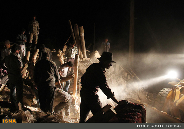
Fig7.
 وبلاگی برای دانشجویان مهندسی زلزله و دیگر گرایش های مهندسی عمران می باشد که شامل دانلود نرم افزارهای مختلف و مطالب و موضوعات مرتبط با این رشته است.