گزارش ویژه به نقل از سایت www.emsc-csem.org
Mw 8.9 NEAR EAST COAST OF HONSHU, JAPAN on March 11th 2011 at 05:46 UTC
Last update 2011-03-11 12:35 UTC
On March 11th, 2011, a magnitude Mw 8.9 earthquake occurred Off Coast of Honshu Island, Japan at 14:46 local time (05:46 UTC). It is currently followed by a serie of aftershocks, with 11 earthquake of magnitude larger than 5 in 2 hours.
The earthquake epicentre is at sea, about 100km off Miyagi with a depth of 22 km. It has been largely felt until Tokyo about 400 km away. A tsunami wave has been generated on the pacific Coast with current reports of more than 4 m high waves. Information in the Sendai harbour (North Japan) reports a wave of 10 m.
This earthquake is the largest recorded in Japan in the last 140 years, and is among the 5 largest earthquakes recorded worlwide.
Two days earlier (March 9th), an earthquake occurred also off the east coast of Honshu, about 35 km away from the today’s earthquake. More information are available here: http://earthquake.usgs.gov/earthquakes/eqarchives/poster/
More information on the main shock is available here.
Felt & Damage reports
Witnesses report that the shaking lasted for about 2 minutes. It was largely felt until Osaka, about 800 km away. It has also been felt in Beijing, 2500 km away from the earthquake.
The current death toll is estimated to 44. Many people are also reprted missing.
Large damages are reported, 6 important fires are taking place in Tokyo. Airport access is damage. Electric power is cut for 4 millions people. But no nuclear power plant is affected.
Tectonic settings
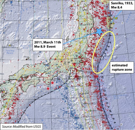
The earthquake involved a thrust fault with displacement up to 10 m.This region is located on the subduction zone boundary where the Pacific Plate subducts beneath the Eurasian Plate. The pacific plate moves approximately westward with respect to the North American plate at a velocity of 83mm/year. The rupture length may be up to 500 km, with a southward direction along the Japan Trench. More information are available here: http://pubs.usgs.gov/of/2010/1083/d/
Source: USGS
The 03/11/2011 earthquake occurred near the east coast of Honshu, it is the result of thrust faulting about 200km west of the subduction zone (Japan Trench). This boundary corresponds to the Pacific plate diving below the Eurasian plate
The latest major event in the region occurred on March 2nd, 1933 with magnitude Mw 8.4 on the Sanriku coast. It was located 140 km North East of the today’s earthquake.
In january 1995, a magnitude 6.8 affected Kobé (West of Japan), the most damaging and deadly earthquake in the country.
Tsunami information
A large tsunami is currently sweeping Japan and the Pacific Ocean, with reports of major waves up to 10 m within Japan. Coasts of Hawaii are currently being evacuated.
| The Japan Meteorological Agency is issuing the tsunami warning (http://www.jma.go.jp/en/tsunami/) |
The National Oceanic and Atmospheric Administration (NOAA) predicts when tsunamis will hit. |
|
|
|


|
|
| Source: BBC |

 Japan Meteorological Agency Tokyo, Japan Pacific Tsunami Warning Centre Hawai, USA
 |
 |
|
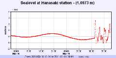
Sea level monitoring in Hanasaki, Japan Source: IOC, other measurements available |
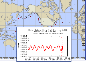
Water column height Source: NDBC/NOAA |
Video of the tsunami (source: CNN)
Aftershocks locations
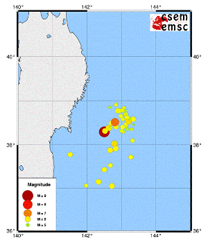
From 09/03/2011 until 11/03/2011 11:00 UTC, 47 events of magnitude larger than 4.5 have occurred in a region of about 200 km2
Send us pictures or videos
You were on the spot and you have taken photos or videos of earthquake effects (on buildings, ground, landscape), please send us your files. Send them by mail, MMS or upload them directly from your computer. Just click on the link below :
Send us pictures or videos of the main shock effects
After validation your files will be displayed on this page.
Epicenter location
 Main Shock Epicenter Location |
 Past Regional Seismicity as from the ISC catalogue (1964-2004) and EMSC Real Time catalogue (2005-today) |

Quick Moment Tensors
 وبلاگی برای دانشجویان مهندسی زلزله و دیگر گرایش های مهندسی عمران می باشد که شامل دانلود نرم افزارهای مختلف و مطالب و موضوعات مرتبط با این رشته است.